Peppered along roadways both big and small in Allegheny County are signs with colored circles: "Green Belt" or "Orange Belt" (or Blue, Yellow, Red) with a circle of the corresponding shade. If you've driven on a belt -- and most likely you have -- you've probably noticed the signs.
You probably also noticed that belts are not exactly shortcuts. One friend posits that they are for tourists; my father thinks they are truck routes. No one knows for sure what purpose they serve.
Except for Steve Smallhoover. An amiable belts advocate, Smallhoover is a roads division assistant manager at the county's Department of Public Works. He explains that county roads were set up along a radial design, wherein all roads lead to Downtown Pittsburgh. If you look at a map of the county, you can clearly see this. The Beltway System, he says, "was meant to relieve congestion in the Downtown area." In other words, if a driver wasn't headed to town, the belts were a way that he could travel to avoid it.
The Beltway System was designed after World War II by the ironically named Joseph White, a public-works employee. "They were all set up at once using primary colors that were readily available [in paint] at the time," Smallhoover says. The most outlying in this rainbow of belts around the city is the Red Belt, the closest to the city, the Blue Belt. (The Purple Belt is not part of the Allegheny County Beltway System; it was set up by the City of Pittsburgh to guide tourists to points of interest in and near Downtown.) The belts don't cross each other. They are each self-contained, not sharing communities or roads. It's wondrously clear on a map that the belts are each off on their own, with Pittsburgh as the bull's-eye.
Smallhoover thinks the development of the belts was prescient. "No real construction was done" to create the belt system, he points out; the signs were simply posted along already-existing roads. "However, if you look at a map from the '40s, and see how they set it up, there is a remarkable correlation between traffic generation along these routes and current day. The people have either followed along where the Beltway System is subliminally, or the system was set up so well, they saw where these were going to be growth areas 50 years hence."
The Parkway, as most people know it, east to west, was done by PennDOT in 1955, well after the belts. Yet it was and remains accessible to many of the belts, and vice versa.
The department for which Smallhoover has worked for 19 years doesn't know how many people use the belts. But, he avers, "People use the road every day whether they realize it or not. You have people only using portions of it. But it is heavily used."
In the 1960s, the new Parkway, the birth of interstate highways and other transportation improvements took a toll on the Beltway System. In short, it was neglected. "As a wayfinder system," Smallhoover says, "it's only as good as the signs that are kept up." A concerted effort was made in the 1970s to revamp the signage along the belts. Thirty years later, it continues to be well maintained.
"I get calls all the time, somebody knocked down a sign or something," Smallhoover reports, delighted.
The belts aren't necessarily a faster way to get where you're going, especially on weekends, but Smallhoover discounts this. "A lot of that has to do with development along the way. You're not coming into town, but you still have to follow the same traffic patterns as everyone else." Suburban sprawl and traffic congestion are problems on the belts as well as anywhere else. The original purpose of the Beltway System has been modified. "It's still a way to keep you from coming into town. It's now a well-defined route of major roads," he says.
Smallhoover explains the classification system for roads. "There's a hierarchy of roadways. Local roads' primary purpose is land access. At the upper tier, you have strictly interstates -- which could be interstates, parkways, turnpikes. The primary purpose of those roads is mobility. In between, you are balancing mobility and land access."
In between, you have the belts. But the other genius of the Beltway System in Allegheny County? "[They] were developed long before the functional classification system [of roads was developed]. There were a lot of very smart people who have done a lot of work over the years, and sometimes it's not always necessary to change what they've developed because they've done such a good job."
Not all of the belts are closed loops; the Red and Green Belts are more like a belt still in jeans crumpled on the floor. The Beltway System is a total of 301 miles of roads around Allegheny County, according to a county map. The map states the belts "are not intended as high-speed routes, but simply provide guideways for motorists unfamiliar with certain portions of the County." If that sounds like, "If you're lost, the belts can help you," that's not too far off another of their purposes. The beltways cross so many major roads in Allegheny County -- from the Pennsylvania Turnpike to Route 51 -- that they can easily dump you on the route you would use to get home. From anywhere. When he lived in Wexford, my husband's cousin Michael used the Orange Belt to get home from Burgettstown one night. It was the long way home, but virtually traffic-free! "I just remembered when I saw the sign," Michael says, "I thought to myself, ‘Hey, I live near the Orange Belt.'"
What Color is My Beltway Loop?
(The Beltway Tour)
The Blue Belt
The Blue-Collar Worker
This belt is closest to the city, and takes you through Crafton, Ingram, McKees Rocks and Homestead, among other formerly industrial neighborhoods. It is also probably the twistiest and turniest of the belts, and has the most traffic signals and stop signs -- again, due to its proximity to the city.
Length: 40 miles, a complete circle.
Driving Time: About two hours.
Belt-marking Signs: Frustrating. You will find yourself guessing at a couple of intersections, notably Pioneer Avenue and Noblestown Road.
Traffic: Noticeably trafficked, and with plenty of back-ups at rush hour at major intersections (Becks Run Road, Pioneer Avenue, Route 51).
Unique Belt Feature: A memorial along Becks Run Road where a carload of teen-agers lost control of their car. It is easy to speed along Becks Run, especially when there isn't much traffic.
Commerce: Plenty of businesses are set up along the Blue Belt, from the small storefronts of Dormont along Potomac Avenue and McKees Rocks along Crafton Boulevard, to the Pittsburgh Center for the Arts in Shadyside, to my personal favorite community of Millvale and its business district along Evergreen Avenue.
Standout Businesses: Dry ice paint ball at McNeilly Ice Company and the Evergreen Avenue School of Knitting.
***
The Green Belt
The Debutante
Although it runs through gorgeous neighborhoods, it doesn't have a lot going on otherwise -- no weird signs and a dearth of lawn ornaments. It's thankfully free of suburban sprawl, although it crosses McKnight Road, the epitome of sprawl.
Length: 34 miles.
Driving Time: An hour and a half.
Traffic: At the time I drove it, at 2 o'clock on a Tuesday afternoon, not a lot.
Belt-marking Signs: Adequate. If you don't see a sign right at an intersection, look across the road or to either side. There's one in sight.
Commerce: Running near several major roadways, you can get off the belt around McKnight to go to any of the malls or plazas there; or you can jump off at the Highland Park Bridge to head to Waterworks.
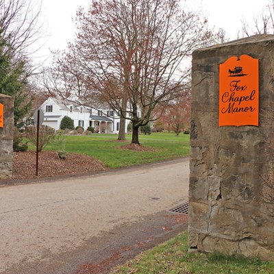
THE Neighborhood: Fox Chapel.
Gets You To: The Hartwood Mansion and Hartwood Acres, home of many a free summer concert. Incidentally, the traffic will back up on a Sunday when there's a concert.
Yellow Belt
The Everyman
This belt goes through upscale, middle-class and working neighborhoods, from Mount Lebanon and Robinson, to Harmar and Kilbuck, to Carnegie and Wilmerding.
Length: 80 miles, a complete circle.
Driving Time: At least three-and-a-half hours.
Traffic: Less than the Blue Belt, but gets heavy at rush hour, especially around Century III Mall.
Belt-marking Signs: Good and consistent.
Best Signs, Part I: The Wilmerding sign, perched on a hillside above the borough of Wilmerding, a la the Hollywood sign. Joe Hartzell, borough manager, explains, "It was put up for the borough's 100th anniversary in 1990. We light it up at night now."
Best Signs, Part II: In Oakmont, a large sign that reads: "CAT CROSSING The home of Pudgie Wudgie." There's no answer at the house, although I would assume Pudgie Wudgie is home. Or across the street.
***
The Orange Belt
The Outdoorsman
The belt is so long because one of its primary purposes is to serve the Allegheny County Parks. Most of the parks abut the Orange Belt.
According to Parks Director Andrew Baechle (pronounced "buckly"), the location of the parks along the belts is deliberate. "[The Park Department] wanted a park to be accessible within 15 minutes of anywhere in Pittsburgh," says Baechle. He wasn't around when the parks were set up, but he guesses that the people who were saw areas of opportunity along the belts, and used those roadways to their advantage.
Adds the road division's Smallhoover, "Parts of the belts were done specifically to get you to the county parks. The original parks, North and South [parks] were bought in the 1930s by [County] Commissioner John Kane. At the time, there was controversy because most people in the county thought nobody would ever go to North or South parks and it was a waste of public money." Other parks came along later, mostly in the 1960s.
Length: 109 miles, a complete circle.
Driving Time: From the Moon business district to Monroeville (about three-quarters of the belt), four hours.
Belt-marking Signs: The best of the belts, with no guessing or confusion.
Traffic: Not so much, especially in the more rural areas north, such as Deer Lake. On the weekends, it may get crowded by the parks.
Best Sign: I get detoured off the belt near Sewickley Hospital, and into the small community of Aleppo. I am roughly parallel to the belt. I am tempted to speed because, after all, they don't have police here. I see a couple of signs saying, "We want our own police back." Which makes me wonder whose police they have, and if that's cost-effective.
Commerce: This belt divides its time between rural areas near the parks and small business districts. You can stop at "Old Wexford" and have a bite at the Post Office Deli; you can shop the Moon Business District; or you can head for a major shopping day at the mall in Monroeville.
Surprise!: Allegheny County has another airport! The Rock Airport, with two runways and several hangers is on Crawford Run Road. According to www.airnav.com, this airport averages 36 aircraft operations a day, including local and transient general aviation (more of the former). Among the services offered are flying instruction, minor repair and hanger rental.
***
Red Belt
The Sunday Driver
This belt meanders through rural towns in north Allegheny County. If you were traveling from Leet to Fawn, you would use this belt. Otherwise, I don't know why you would travel it, except for a scenic drive.
Length: 38 miles.
Driving Time: One hour.
Signage: Although sometimes far apart from each other, the signage on the Red Belt is good enough that by the time you're wondering if you're still on it, you'll see a sign. If anything, these signs show the most age; many are cracked or so faded it looks as if you're on the "Pink" Belt.
Traffic: More than I expected, at 2 p.m. on a Monday, which is to say I'm not alone on the road at any time. The belt comes up on Route 8, Interstate 79 and Route 28, but even so, I would be surprised to hit an actual traffic jam at any point, day or night, weekend or not.
Best Sign: An actual "Duck Crossing" sign, a big yellow diamond with the silhouette of a duck.
Commerce: Surprisingly little. Lots of local bars, small eateries, a few 7-Elevens -- and some kids setting up a Kool-Aid stand. Near Route 8, there is an extensive housing development, and you might expect to see a mall or plaza shopping area. But the next shop I come across was Trees Market, which looks like a very nice general store.
Unique Belt Feature: Aside from being the belt where I most often almost run over wildlife, two features of note are the waving American flag painted on the side of a barn at Easterly Farms, and -- finally -- lawn ornaments. (I really expected to see more along the belts.) In front of a small house are a collection of Warner Bros. characters, including a Tweety Bird that's about two feet tall, and the Seven Dwarfs (from Disney), who, in a twist of perspective, are shorter than Tweety.
Creepy Unique Belt Feature: I never drove past more cemeteries in 38 miles in my life.
Rainbow Connections
Everything you ever wanted to know about the county's colored Beltway System (but were afraid to get off the Parkway to ask)